
In 1947, the United States Navy was the predominant Navy in the entire world.
The buildup of American naval forces during the Second World War resulted in an excess of ships when the war was finally brought to a conclusion. The quiet revolution that came to be known as the Cold War was just beginning to be really understood.
The role of a powerful Navy in a global community was questioned by many people both here and abroad. But a peaceful use of these forces had been envisioned by planners and the conquest of the natural barriers represented by the ice caps was a logical use of all this power and flexibility.
I had never heard of Operation Highjump until researching information on the USS Sennet SS 408. Sennet was the only submarine involved in the mission but she was useful in experimenting with a new type of ice detection system that was a forbearer to the equipment that would be used in the near future.
But this is a great story from January 1947 concerning the entire operation. In the third to the last paragraph, the writer insisted that this operation was not as a result of any race with any other nation. Yeah, right. Even though some in the administration still harbored visions of global peace and cooperation, even the dullest of minds could see the fall of the countries surrounding the Soviet Union proper and the coming failure of China to fend off a communist dictatorship.
This is the story of Operation Highjump
MEN AGAINST ICE – ALL HANDS January 1947

EXPLORERS have found it cruel and rugged, colder than the Arctic by an average of 40 degrees, and swept by pounding gales and blinding Snowstorms.
It is described as the “battleground of a sinister ice age in its flood tide,” and within its confines there is practically no animal life—and an even greater scarcity of plant life.
That’s Antarctica, the frigid, ice capped continent at the bottom of the world, where the Navy has sent a task force of 4,000 men and more than a dozen ships.
Nicknamed Operation HIGHJUMP but technically termed the Antarctic Developments Project 1947, the Navy’s expedition into the “Deep South” is concerned primarily with testing standard naval ships and equipment under frigid conditions and training personnel in that type of operation.
In carrying out these basic purposes, the project will attempt to explore as much as possible of Antarctica’s area of nearly six million square miles, an expanse nearly equal to the combined areas of the U. S. and Europe. Of this, nearly four million square miles —an area greater than the U. S. and Mexico—still are unexplored.
The expedition, largest ever to enter the Antarctic, was scheduled to arrive early this month, at the beginning of Antarctica’s summer season. It is expected that no severe weather will be encountered—probably nothing worse than 30 degrees below zero, a mere nothing compared to the region’s winter.
Members of the expedition will find that it isn’t necessary to delve into the past to learn about the ice cap which covers land during an ice age. In Antarctica the ice age still exists. The continent is covered with an ice cap such as thousands of years ago covered most of the top of the world, reaching as far south as Cincinnati and New York. Since the glacial period up north ended, the top of the world has been almost a balmy tropical paradise compared to the Antarctic.
Although there is practically no animal life on Antarctica, within the corresponding area around the North Pole there are year-round residents— the musk ox, polar bear, fox, wolf, Arctic hare, reindeer, seal and walrus. Life on Antarctica normally is restricted to its ice-bound shore line, with birds and seals its only continuous inhabitants. Although these represent comparatively few varieties, they exist in large numbers and find their entire food supply in the rich marine life of the coastal waters. One of these permanent residents living on Antarctica’s rim is the haughty white vested penguin. Seals and whales abound in the Antarctic, but the whales annually migrate to warmer waters to breed, returning to feed in South Polar waters in the spring.
Extensive studies of the seals show that some do not migrate north in the fall, but in failing to do this they must wage a continual battle for existence during the long winter night. Any opening in the ice that is free for more than a few hours freezes over solidly, and the seal must keep gnawing open a hole through which to breathe.
Although the Arctic regions abound with several hundred species of flowering plants and ferns, the Antarctic supports only two forms of tufted grass, and these cannot by any stretch of the imagination be said to flourish. This poverty of plant life on the continent is due, fundamentally, to a low mean temperature. In some places favorable to growth, an impoverished flora of moss and lichen may be found. Shingle beaches and bare rocky coasts are most suitable for plant life. These, however, usually are occupied during the summer by penguins in large numbers, and the plant life has difficulty in surviving. Sometimes vegetation is found in moist valleys protected from winds, on narrow ice-free coastal rims, or on isolated nunataks (islands of rock standing above the surrounding ice sheet) protected from the winds and exposed to the northern sun.
Antarctica’s climate, in spite of its rigors, has been reported as extremely healthful. Respiratory diseases, for example, are rare because conditions are unfavorable for the growth of bacteria. Any disease germs encountered usually have been brought by the visitors themselves. Insect pests are unknown.
Antarctica is contained almost entirely within the Antarctic Circle. The Ross Sea, South of New Zealand, and the Weddell Sea, south of Brazil, take big bites out of the continent. During the summer period, which corresponds to the U. S. winter, ships in either of these seas may approach to within 700 miles of the South Pole. But only across the shelf ice massed in the southern part of the Ross Sea has the South Pole so far been reached.
Antarctica is the world’s highest continent, averaging about 6,000 feet in altitude. Many of the charted peaks tower higher than Mt. McKinley, highest mountain in the U. S. The South Polar plateau is about 10,000 feet above sea level. Although 20th Century explorers have viewed nearly two million miles of Antarctica, have mapped the South Pole itself and virtually the full 14,000-mile perimeter of the frozen land mass, the continent still is the world’s great mystery. It is considered “an untouched reservoir of natural resources,” where untold riches lie in their natural state.
The Western shore of the Weddell Sea is formed by the Palmer Peninsula, by which Antarctica reaches furthest north, the tip lying within 500 miles of South America’s Cape Horn. Its mountains are a continuation the Andes Range of South America. The west coast of Palmer Peninsula, because of its accessibility, was well known to sailing fleets long before man became familiar with the massive continent to which it was attached. To the west, between it and the Ross Shelf Ice, lie James W. Ellsworth Land and Marie Byrd Land.
Some of the world’s bitterest winds have been encountered on the Ross Shelf Ice, probably caused by downdrafts of cold air flowing from higher altitudes on the shelf, their velocity reaches more than 50 miles an hour. Also encountered in this area were crevasses so large that they could easily swallow a battlewagon – with enough room left over for a carrier these upheavals give an impressive picture of the mysterious forces at work in the Antarctic.
During a previous expedition, a mountain discovered about 200 miles from the South Pole displayed horizontal beds of sedimentary rock. Here geologists found plant fossils, leaf and stem impressions, coal and fossilized wood. Here, at one of the most south ern mountains in the world, scarcely 200 miles from the South Pole, was found conclusive evidence that the climate of Antarctica once was temperate—or even subtropical!
To give you an idea of the extreme low temperatures which must exist in Antarctica’s interior in the winter, the thermometer at this mountain rose not more than five degrees above zero Fahrenheit and that in the middle of summer!
Just south of latitude 86 degrees, explorers discovered some of the most southerly recorded plant life, tiny primitive lichens growing on the northern exposure of a mountain. The sun is warm enough to melt the snow only for a week or two in midsummer, but the plants during that brief period manage to grow enough to hang onto the thread of life. With this difficult and forbidding environment, the lichens grow no larger than the head of a pin.
Flora collected in Marie Byrd Land was thawed out, showing thousands of microscopic organisms swimming under the glass. They had endured temperatures of 60 and 70 degrees below zero in an encysted stage, coming to life again within an hour after being thawed out. It is thought that some of these may have been carried to the Antarctic on the plumage and feet of birds. Others may have been blown there with the dust of the upper atmosphere, while still others may have existed there for thousands of years. This is one of Antarctica’s riddles.
One riddle which existed for many years, and which was solved by the Byrd Expedition of 1933–35, was the so-called “continental problem.” The question: “Was Antarctica one continent or two?”
So little was known of the coast line of the Pacific Ocean and the Weddell Sea, and of the interior between them, that geographers for years had been speculating on this problem. Some geologists, studying rocks from East and West Antarctica, felt that they were too dissimilar for the two regions to be one. Others reached the opposite conclusion. It was thought by some tidal experts that the behavior of tides in the Ross Sea indicated a sea connection between it and the Weddell Sea, with their water-borne ice barriers extending toward each other through the unknown interior.
This was a problem which had to be solved before geological science could form an accurate concept of the fundamental structure of the great area, and its relationship to neighboring land masses to the north.
It was discovered that the plateau of Marie Byrd Land, adjacent to the Ross Sea, probably rolls unbrokenly from the South Pacific Ocean to the South Pole, extending at least a thousand miles north and south. This, coupled with discoveries of new mountains in ranges running east and west, gave a strong indication that Antarctica is one continent. Long-range patrol planes of the east group of the present expedition hope to confirm this by delineating the coast of the Weddell Sea, the head of which never has been sighted or photographed.
Antarctica has been described as a “place where Nature has time and unhindered space to exhibit her beauty.” The sky and whole snowy earth are alive with lingering colors. Convection currents (which in warmer climates would be called heat waves) add a leaping movement to colors formed by the sun’s reflections from the expanse of ice and snow. The whole scene seems unreal—more so because one cannot use as a measuring stick familiar objects such as shrubs, trees or houses.
Called the “home of the blizzard,” Antarctica is a region whose weather is considered to affect directly the weather of the Southern Hemisphere and possibly, indirectly, that of the entire world. A study of the Aurora Australis (the southern aurora corresponding to the Aurora Borealis of the north) alone would be of interest.
Air chilled by the frigid wastes of the Polar Regions flows toward the equator’s warmer atmosphere, and the warm tropical air rises and circulates back to these frigid zones. World weather is made by the interaction of these great masses of warm and cold air. In order to establish long-range forecasting, it is necessary to know the weather conditions existing at the poles, as well as in inhabited countries. Such a study is one of the expedition’s tasks.
The major part of the large and elaborately-equipped expedition got under way from Norfolk, San Diego and Port Hueneme early last month, and with other ships of the task force was to arrive at three starting points close to the Antarctic ice barrier early this month. The task force is divided into three main groups as follows:
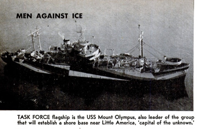
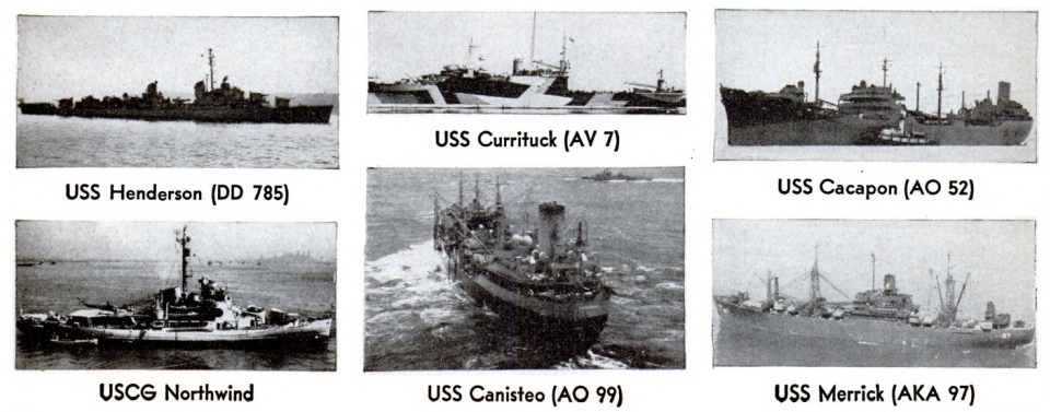
Central group — Flagship and communications headquarters s h i p USS Mount Olympus, Coast Guard ice breaker, USCG Northwind, Navy ice breaker USS Burton Island, cargo ships USS Yamcey and USS Merrick, and submarine USS Sennet.
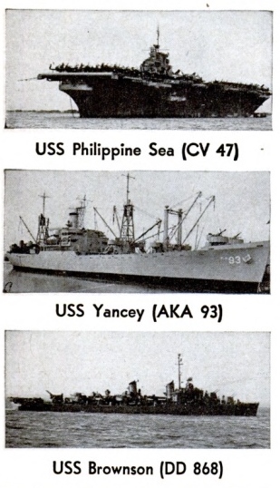
East group — Seaplane tender USS Pine Island, oiler USS Canisteo, and destroyer USS Brownson.
West group — Seaplane tender USS Currituck, oiler USS Cacapon, and destroyer USS Henderson.
Technical control of the expedition is being exercised by Rear Admiral Richard E. Byrd, USN (Ret), famous polar explorer, who is on duty in the office of CNO as adviser on Arctic and Antarctic matters. He has been designated as officer in charge of the project. Rear Admiral Richard H. Cruzen, USN, who commanded the Navy’s Arctic training cruise last summer (ALL HANDS, November 1946, p. 12), is the task force commander. He was Admiral Byrd’s second in command during the 1939-41 expedition, commanding the cutter USS Bear.
Capt. George J. Dufek, USN, a naval aviator and a member of the previous Byrd expedition, commands the east group, while Capt. Charles A. Bond, USN, also a naval aviator and a veteran of wartime aviation in the Aleutians, is in command of the west group.
At a press conference before sailing from Norfolk on the Mount Olympus, Admiral Cruzen said that only the central group will be land based. Neither the eastern nor western group will enter the pack ice, but will conduct their exploratory operations from outside the ice, sending their patrol planes inland in a flight radius of 700 to 800 miles. Since these planes must fly over the pack ice before penetrating the Antarctic interior, their survey range will be lessened.
The east group was to begin air operations near Peter I Island, working around the continent to the east ward. The west group was to head for a point southeast of New Zealand, following the edge of Antarctica around to the west.
Each of these groups consists of a seaplane tender carrying Martin Mariner patrol planes and helicopters, an oiler and a destroyer. They will continue around the continent, exploring inland by air, as far as the short duration of the operation—and the weather—permit.
After arriving at Scott Island, south of New Zealand near the Ross Sea, the central group was to send an ice breaker and scouting planes ahead to find a passage through the pack ice. Once the pack ice was penetrated, the group would enter the Bay of Wales and set up an air base on the Ross Shelf Ice, near Little America.
Little America, “capital of the unknown,” is situated on the shelf ice several miles inland from the edge of the Ross Ice Barrier. It was founded on New Year’s Day, 1929, by the first Byrd Antarctic Expedition, and will be the center of operations of the land-based group.
The operational schedule called for the North wind to open a channel through the pack ice for the Mount Olympus, the cargo ships Yamcey and Merrick and the submarine Sennet. The ships were to follow in column or go through singly, depending upon conditions of the pack ice. Their passage may take a few hours, or the better part of a month. The icebreaker Burton Island, which is to be a component of the central group, will join the expedition late this month.
There was a possibility that the expedition would not be able to reach the Bay of Wales, near which Little America is situated. In that event, another point of entry to the shelf ice would be selected, such as Okuma Bay, Discovery Inlet or Kainan Bay. This uncertainty is typical of operations in the Antarctic, where conditions change rapidly, from day to day. Antarctica’s ice bulwarks have withstood man’s attacks for more than a century. It is here, within the Antarctic Circle in an area of heavy pack ice called the Devil’s Graveyard, that one finds the heart of the greatest iceberg-producing region in the world. During the 1933-35 expedition, 8,000 bergs were sighted in one 24-hour period.
By tradition and experience, passage in the vicinity of the 178th meridian East was accepted as the safest and quickest entrance into the Ross Sea, and it was considered foolhardy to try a break through the ice at any other point. However, due to the constantly-changing ice conditions, on a previous expedition the explorers had the amazing luck to find an opening along the 169th meridian West, meeting little pack ice in reaching the Bay of Whales.
With a beam of 63 feet, the Mount Olympus will be one of the largest ships ever to enter the Ross Sea, which inside the pack ice usually presents an expanse of open water swept by a current which skirts the face of the Ross Shelf Ice. The Northwind is a super ice-breaker, 10 times as effective as the Bear, which participated in the last Antarctic expedition. It is believed that the Northwind can batter her way through solid pack ice 15 feet thick on the basis of her performance during last summer’s Arctic cruise.
The Northwind was fitted with a bow propeller to wash ice aside, and tanks fore and aft and on the extreme beams to set up a rolling and pitching motion. These have been removed because they are considered useless in the heavy ice expected enroute to Little America.
On board the Mount Olympus are 57 members of an underwater demolition unit, who will blast away low ice bordering the permanent shelf ice of the Antarctic continent. These men actually may swim in the icy waters fringing the shelf to plant explosives against the ice. They will be protected by rubber suits sealed against leak age, which will cover their entire bodies. Underneath they will wear woolen underwear and clothing.
Admiral Byrd did not accompany the force which sailed for Antarctica last month. He plans to join the expedition late this month, riding down on either the carrier Philippine Sea or the icebreaker Burton Island.
The Philippine Sea will ferry six Navy R4Ds, twin-engine Douglas transports, to a point about 200 miles north of Little America just off the edge of the Ross Sea pack ice. The aircraft will be equipped with jet assisted takeoff gear for the flight from the carrier. The planes will be the first of their type ever launched from a carrier. Special cold weather gear and electronic devices have been installed in the big planes. Extra fuel tanks will extend their range beyond the usual eight to 10 hours. Much of the radar equipment still is on the secret list. It includes devices to pick up geological aspects of the continent and to indicate the composition of the ground under the frozen surface. The planes will have aerial cameras and map making aids. When ready to leave the carrier, they will have ski attachments for landing and taking off in Snow.
Meanwhile, the Northwind will be fighting her way back through the pack ice to come alongside the carrier. The icebreaker will discharge mail, and take on mail and additional equipment, ferrying it back to Little America. To commemorate the 1947 expedition, a distinctive cachet will be applied to letters mailed from the Mount Olympus. Before the task force sailed from the U. S., philatelists were given an opportunity to have covers mailed.
Seaplanes of the wing groups, which start their operations about a thousand miles to the east and west of Little America, are not expected to find especially good flying conditions. The standard Navy patrol planes, winterized and equipped with special photographic gear, will have to find relatively smooth seas in which to land —probably in the lee of some piece of land or within a lake formed by floating ice. There will be no accurate weather forecasts, no loran. Once the planes leave their tenders and head in toward the continent, they will fly over pack ice which even the most modern and powerful icebreaker cannot penetrate. What, then, will happen if the planes are forced to land?
It is true that rescue operations will be difficult because of the high mountain ranges over which the planes must fly. However, the land is covered with ice and snow, and the aircraft probably can make safe landings, even if they can’t take off again without necessary skis. For rescue operations, therefore, helicopters will be carried by the seaplane tenders. Although these have short flight ranges, caches of gasoline in strategic points will extend their range so that they can rescue any crews forced to land. Crews will be kept alive until rescue comes by survival equipment, which includes emergency radio equipment for communication with the home base. On long-range flights, the crews will wear heavy clothing rather than heated suits, to be sure of protection against the weather in the event of forced landings. The equipment also includes more clothing, skis, tents, and a 60-day supply of food. A large portion of the food will be old-fashioned pemmican, the preserved meat explorers have been using for the last hundred years.
The expedition will take full advantage of the photographic developments achieved during World War II, and in addition will have the advantage of the trimetrogon camera. This is a three-in-one camera which takes a vertical shot to cover what is beneath the plane, and also two oblique shots to give a continuous photo graphic image from horizon to horizon. The pictures will be taken continuously to give a complete photo graphic coverage of the territory traversed by the planes.
These photos of a large section of Antarctica—the expedition expects to explore two million square miles from the air—will show the general con tours of the land, mountain ranges, glaciers and ice fields. Also, they will give a general picture of what any ground parties might encounter. The Antarctic coast will be outlined also, in many places for the first time.
The expedition doesn’t expect the interior of the continent to be feature less, even though it is described as a frigid, barren wasteland. It is expected that many new mountain ranges will be discovered. The explorers want to know the character of these strange, unknown lands. Only about a tenth of the continent has been sighted, and of that, only a small portion photographed.
Weather and altitude permitting, each flight probably will cover from 700 to 800 miles into the interior. The photographic coverage from the central group will include the South Pole as a routine mapping operation. In addition to twin-engine Douglas transports, helicopters, and PBMs, the expedition will use two Grumman amphibians, two SOC float planes, and one Noorduyn Norseman skiplane.
Men working and living ashore at the central base will be housed in tents having wooden floors and heated by oil stoves. Tents are being used instead of huts to save valuable time. The base will be of a temporary nature, but a small camp consisting of nine winterized Quonset huts with supplies for 18 months will be established. If any of the parties in the interior are in difficulty when the ships are ready to sail, this camp can be activated for rescue operations.
Aside from pemmican, standard polar item, no special foods were taken. The food is standard, including huge quantities of quick-frozen foods. Because the party will be away from civilization for four to five months, the men are being given as wide a variety of food as possible, with the realization that men in cold climates eat much more than they do in warmer weather.
There was no resupply for the ships of the expedition after they left the U. S. Each is self-sustaining, carrying all its own supplies. Those for the base camp were carried by the cargo vessels. The two big tankers have fuel to supply the ships and air craft in the Antarctic and get them home. The loading plan was reminiscent of Pacific invasions. Huge supplies of dry stores were stocked, as well as “morale” items in quantity, and thousands of pounds of coffee and case after case of cigarettes.
The long voyage to and from Antarctica and off-duty time was expected to be boring for the men. For that reason, ample supplies of movies, radios, games, cameras and other recreational gear were taken along. In addition, members of the expedition are being given an opportunity to learn hobbies such as carpentry and leather craft, with a good supply of hobby craft equipment included. The educational program of the U. S. Armed Forces Institute will be available to all hands in their spare time, and scientists and leaders of the project will present talks to the crews of the ships so that they will more fully understand what is being done and will have a deeper interest in the operation.

In addition to Operation HIGHJUMP, there will be at least three other projects in Antarctica. One of these is a U. S. expedition which has been out fitted under auspices of the American Antarctic Society. Russia has announced that it will have a party of scientists in Antarctica. It is expected that at least one British expedition will be present, because that country has occupied the old U. S. exploratory base at Marguerite Bay, 1,500 miles from Little America, since 1942. Since the Marguerite Bay base was only of secondary importance during the previous U. S. expedition, its occupation by the British will not hamper the Navy’s current operations. With operation HIGHJUMP’s activities centered at Little America, no conflict of interests with other expeditions is anticipated, and the Navy stands ready to cooperate with explorers of any other nation who may be encountered.
In regard to the so-called “uranium race,” which was given considerable attention in the press, leaders of the Navy’s expedition, before departing for Antarctica, pointed out that when the project first was planned there was no thought whatever of making a Search for uranium. There are geologists along, and should they dis cover uranium, it will naturally be of interest. But there will be no special attempt to locate the precious metal, and it does not form one of the purposes of the trip. Nor is the expedition in any sense a “race” with any other nation.
Exploration of Antarctica will continue as long as weather conditions permit, but it is anticipated that the ships will have to push their way out of the pack ice by the end of March, arriving home in late April. While the expedition is primarily of a military nature, it will afford an unequalled opportunity for amplifying existing scientific data. The Antarctic is considered a fertile field for scientific research—possibly the most fertile left in the world. Full advantage has been taken of this opportunity for research. Scientists of other govern mental departments in a number of specialties are participating. The Army, Weather Bureau, Coast and Geodetic Survey, Coast Guard, U. S. Geological Service, Hydrographic Office, the Navy’s material bureaus, and other government scientific agencies have provided technicians. Full news coverage is being given by press, radio and magazine correspondents. Three hundred scientific personnel, with 22 civilian and 35 Navy senior scientists and their technical assistants, are accompanying the expedition.
The Navy has had an interest in the Antarctic since the first naval expedition under Lt. (later Rear Admiral) Charles Wilkes, USN, in 1838, and this interest is expected to continue in the future. The war intensified the Navy’s program of scientific research. With much new equipment added to facilitate scientific research. It is the Navy’s policy to continue to extend scientific research on as broad a scale as possible, in every field. The Antarctic provides a vast proving ground for many scientific projects, and the Antarctic Developments Project 1947 is only one more step in the Navy’s peacetime program of science.


Thanks for the historical info on Stennett and Operation Highjump. You always teach me.
Thanks Nancy. This one was a fun story to capture.
Mac
was on the sennet when she was on her last sea duty & ended up with a test torpedo ,still spinning sticking out of her viewing window. ’twere crazy and cool @ the same time. wish i had a picture of that.